
Solutions by Industry
Our autonomous platforms solve real operational challenges across multiple industries.
Select your industry to see recommended platforms and applications.
-
Offshore Energy
Platform inspection, pipeline surveys, subsea infrastructure, offshore wind
-
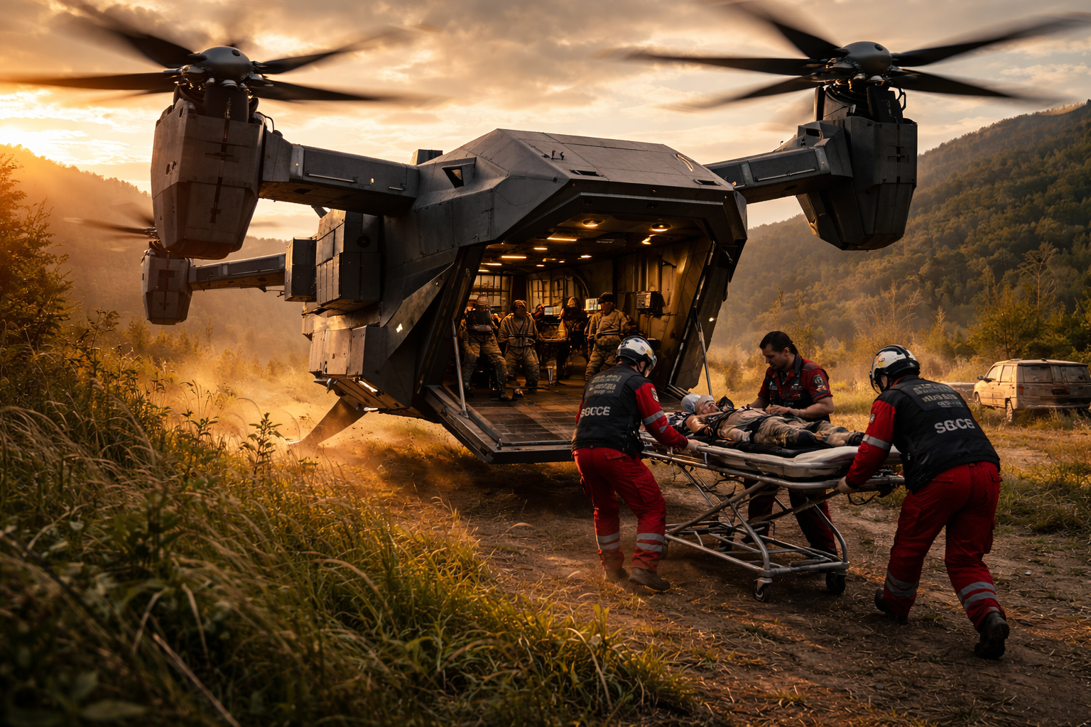
Emergency Response
Disaster relief, search and rescue, medevac, firefighting support
-
Infrastructure
Power lines, bridges, pipelines, towers, utility inspection
-
Agriculture
Crop monitoring, precision spraying, livestock, land survey
-
Environmental
Wildlife monitoring, ecosystem surveys, pollution detection
-
Maritime
Port security, hull inspection, aquaculture, coastal surveillance
-
Critical Infrastructure Security
ICS/SCADA monitoring, network threat detection, industrial cybersecurity
-
Law Enforcement & Defense
Crime scene reconstruction, after-action review, spatial intelligence
-
Construction & Real Estate
Site visualization, virtual staging, BIM overlay, investor presentations
Offshore Energy

Challenges We Solve
- High cost of vessel-based inspection operations ($50K–$150K per day)
- Weather-related operational delays and seasonal access windows
- Safety risks for divers and personnel on platforms and subsea
- Limited inspection frequency due to logistics constraints
- Deep-water infrastructure beyond diver depth limits
Recommended Platforms
| ATLANTIS | Autonomous subsea inspection, pipeline surveys, foundation assessment |
| AquaGuard (Inspect) | Hull inspection, cathodic protection surveys, riser and mooring checks |
| LEVIATHAN | Deep-water crewed inspection, complex repair oversight, well intervention support |
| Voyager | Long-range platform surveillance, wind farm surveys, maritime patrol |
| Scout | Above-water asset inspection, flare stack surveys, topside monitoring |
Emergency Response
Challenges We Solve
- Rapid situational awareness in chaotic disaster environments
- Delivering critical supplies to cut-off or hazardous areas
- Locating survivors in rubble, floodwaters, or remote terrain
- Post-disaster damage assessment across large areas
- Coordinating multi-agency response with shared intelligence
Recommended Platforms
| HERCULES | Emergency cargo delivery, medevac, firefighting water drops |
| Scout | Rapid-deploy aerial recon, structural assessment, thermal survivor search |
| Atlas | Heavy supply delivery to isolated areas, equipment transport |
| Voyager | Wide-area damage mapping, communication relay, corridor survey |
| AquaGuard (SAR) | Underwater search and rescue, flood zone victim detection |
| PRISM | AR damage assessment overlay, resource staging visualization, evacuation planning |
| FrostGuard | Autonomous runway and road clearing during winter storm emergencies |
Infrastructure Inspection
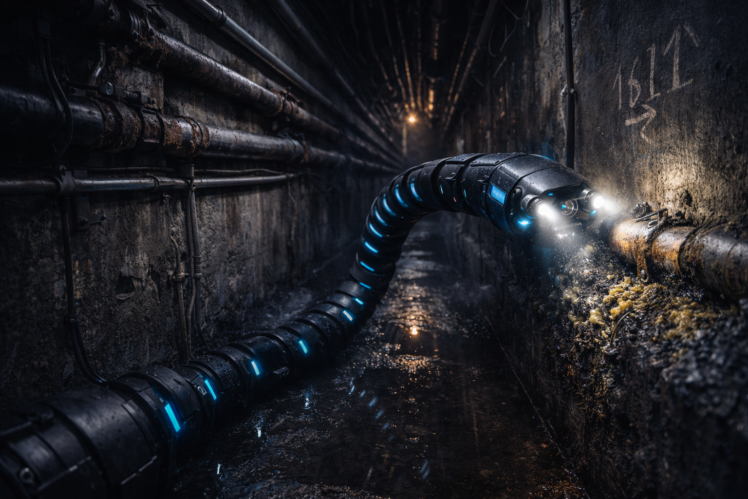
Challenges We Solve
- Manual inspection of hard-to-reach assets (towers, bridges, pipelines)
- Safety risks for human climbers and confined-space workers
- High cost and low frequency of traditional inspection cycles
- Aging infrastructure requiring more frequent monitoring
- Nuclear facility inspection in radiation-hazardous environments
Recommended Platforms
| Scout | Tower, bridge, and building inspection; thermal imaging; confined space |
| Voyager | Long-corridor pipeline and power line surveys |
| Nuclear Robot | Reactor inspection, spent fuel pool surveys, hot cell operations |
| CoreHound | Underground utility mapping, tunnel inspection, fissure exploration |
| NEMESIS | SCADA/ICS network monitoring for infrastructure control systems |
Agriculture
Challenges We Solve
- Monitoring thousands of acres efficiently with limited labor
- Detecting crop stress, disease, and pest damage early
- Precision application of inputs to reduce waste and cost
- Livestock monitoring across large rangelands
- Accurate land survey and drainage planning
Recommended Platforms
| Scout | Field-level crop inspection, NDVI imaging, spot spraying |
| Voyager | Large-area mapping, ranch/livestock monitoring, boundary survey |
| Atlas | Heavy spray payloads, seed distribution, supply delivery to remote sites |
Environmental Monitoring

Challenges We Solve
- Monitoring remote or inaccessible ecosystems consistently
- Wildlife population counts and migration tracking
- Detecting pollution, oil spills, and illegal dumping
- Collecting ocean and atmospheric data for climate research
- Deep-sea ecosystem observation and hydrothermal vent studies
Recommended Platforms
| Voyager | Wildlife surveys, habitat mapping, pollution corridor tracking |
| Scout | Localized sampling, nesting site monitoring, species identification |
| ATLANTIS | Ocean floor mapping, water quality sampling, reef assessment |
| LEVIATHAN | Deep-sea ecosystem research, hydrothermal vent studies, benthic surveys |
| CoreHound | Geothermal monitoring, tectonic sensor deployment, subsurface sampling |
Maritime Operations

Challenges We Solve
- Port and harbor security across large waterfront areas
- Vessel hull inspection without expensive dry-docking
- Aquaculture pen monitoring and environmental compliance
- Coastal surveillance and border patrol coverage gaps
- Mine countermeasures and underwater threat detection
Recommended Platforms
| AquaGuard (Sentinel) | Autonomous port patrol, continuous underwater surveillance |
| AquaGuard (Inspect) | In-water hull inspection, propeller and rudder survey, biofouling assessment |
| AquaGuard (Defense) | Mine countermeasures, anti-sabotage patrol, threat detection |
| ATLANTIS | Subsea cable and pipeline route survey, seabed mapping |
| Voyager | Coastal surveillance, maritime domain awareness, vessel tracking |
| Scout | Close-range ship inspection, pier security, rapid response |
Critical Infrastructure Security

Challenges We Solve
- Legacy ICS/SCADA systems with limited visibility and no intrusion detection
- Unknown or undocumented protocols running on operational networks
- Insider threats and supply chain compromises in industrial environments
- Compliance requirements (NERC CIP, IEC 62443, NIST CSF)
- Bridging IT and OT security with a unified monitoring platform
Recommended Platforms
| NEMESIS | Neural protocol auto-dissection for unknown industrial protocols. Real-time anomaly detection across Modbus, DNP3, OPC-UA, and 12+ ICS protocols. 3D network topology visualization. |
Industries Served
- Power & Utilities — Grid SCADA, substation monitoring, smart meter networks
- Oil & Gas — Pipeline SCADA, refinery DCS, well-site automation
- Water & Wastewater — Treatment plant controls, distribution network monitoring
- Manufacturing — PLC/HMI network monitoring, production line security
- Government & Defense — Classified network monitoring, facility ICS protection
Law Enforcement & Defense
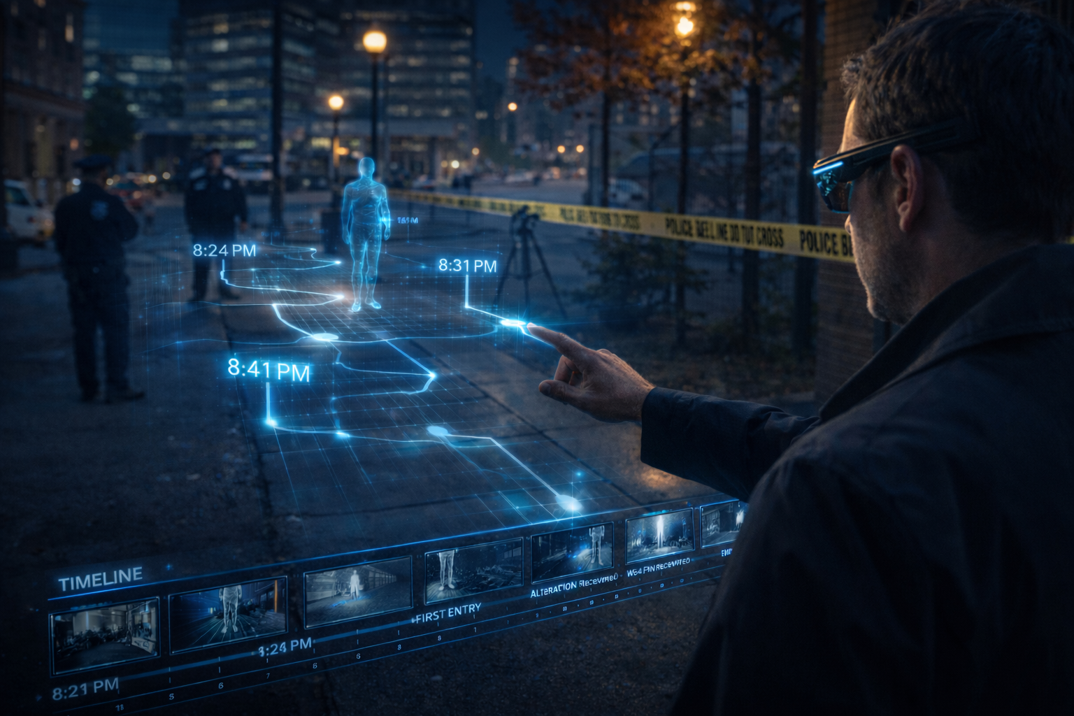
Challenges We Solve
- Reconstructing crime scenes and incidents from fragmented data sources
- Presenting complex spatial evidence to juries and review boards
- After-action review using real terrain instead of flat screens
- Aerial surveillance and situational awareness in active operations
- Secure display of classified intelligence in field environments
Recommended Platforms
| PRISM (LE) | Crime scene reconstruction from body cam, cell tower, and GPS data. Jury courtroom walkthroughs. Suspect movement pattern visualization. |
| PRISM (Defense) | After-action review on real terrain. Convoy and flight track replay from SENTINEL data. Training scenario overlays. |
| SecureAR | Geo-fenced classified display. Secure briefings without paper or screens. Iris-authenticated access control. |
| Scout | Tactical aerial surveillance, perimeter security, rapid-deploy ISR |
| Voyager | Extended area surveillance, border patrol, persistent overwatch |
Construction & Real Estate
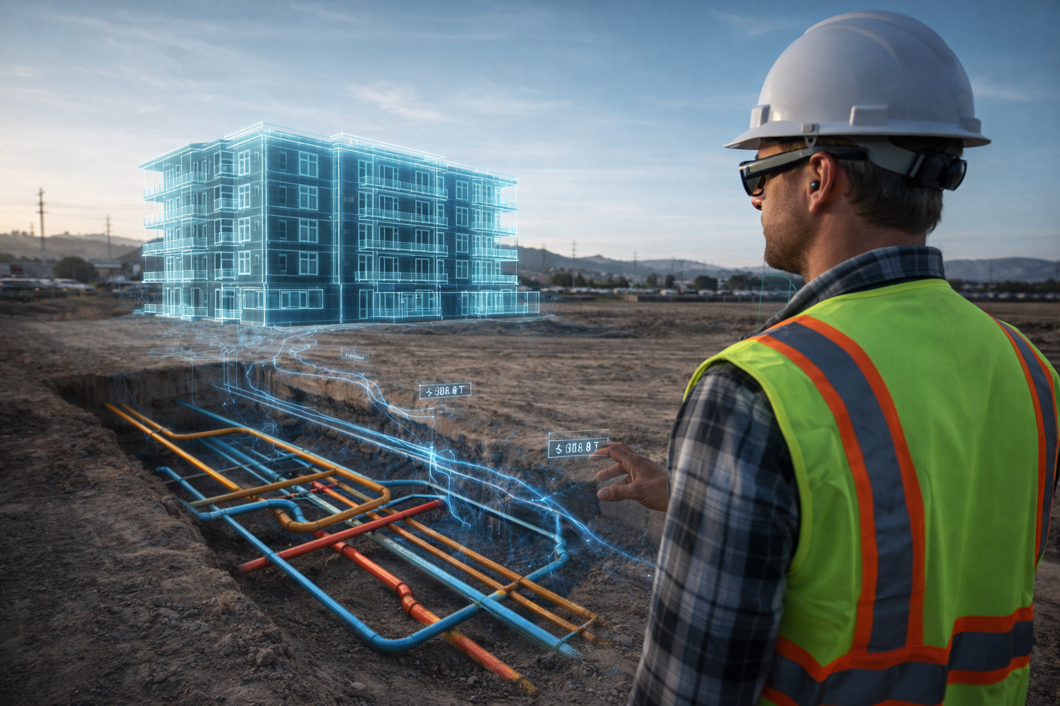
Challenges We Solve
- Communicating design intent to investors, buyers, and community stakeholders
- Costly photo staging and 3D renderings for each property listing
- BIM model visualization limited to desktop screens
- Underground utility conflicts discovered too late during excavation
- Progress tracking across large construction sites
Recommended Platforms
| PRISM (Construction) | Walk through proposed buildings on empty lots. BIM overlay on job sites. Underground utility visualization. Investor presentations at scale. |
| PRISM (Real Estate) | Virtual furniture staging in empty properties. Renovation previews in-situ. New construction marketing before groundbreaking. |
| PRISM (Urban Planning) | Zoning and development visualization for community meetings. Traffic flow simulation. Public engagement. |
| Scout | Site survey, progress documentation, aerial mapping, volumetric measurement |
| Voyager | Large-area site mapping, corridor survey for roads and utilities |
Don't See Your Industry?
Our platforms are highly adaptable. Contact us to discuss your specific operational challenges.